Uncharted Places and the Challenges of Mapping
Some of the most mysterious and least understood places on Earth remain unmapped, hidden from the world’s knowledge. These regions pose unique challenges for cartographers, researchers, and even governments trying to understand and protect them. From remote Amazonian valleys to underwater cave systems, these areas reveal how much we still don’t know about our planet.
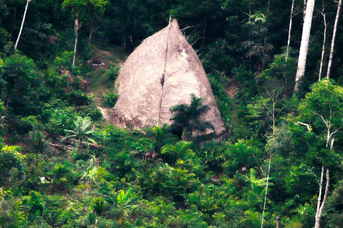
The Vale do Javari: A Region of Isolation
Located in Brazil, the Vale do Javari is one of the most isolated regions on the planet. It is home to as many as 19 uncontacted tribes, who have lived in seclusion for generations. This vast area, roughly the size of Austria, stretches over 33,000 square miles. Unfortunately, this isolation also makes it vulnerable to threats like illegal logging and land encroachment. In 2022, British journalist Dom Phillips and Brazilian activist Bruno Pereira were murdered while working to protect the region, highlighting the dangers faced by those who seek to safeguard these untouched lands.
Slums and the Importance of Mapping
In urban areas, some of the most densely populated spaces are often missing from official maps. Cities like Rio de Janeiro and Lagos, Nigeria, have large slum communities that are not clearly marked on maps. According to a 2022 study published in Remote Sensing, accurate mapping of slums is essential for policymakers to plan infrastructure and allocate aid effectively. Without proper representation on maps, these communities may be overlooked in development efforts, leaving residents without access to basic services.
Sandy Island: A Mystery in the South Pacific
One of the most intriguing examples of an unmapped place is Sandy Island, which appeared on marine charts, Google Earth, and other global maps for years. However, when scientists finally set out to investigate its location between Australia and New Caledonia, they found no island there. Experts believe human error over time led to the creation of this phantom landmass. It's possible that the island never existed at all, or it may have been a temporary feature that disappeared.
Yucatan Cenotes: Hidden Underwater Worlds
The Yucatan Peninsula in Mexico is home to an extensive network of cenotes—underwater caves that have remained largely unexplored since the time of the Mayans. Photographer Klaus Thymann has dedicated himself to exploring and documenting these sites, aiming to raise awareness about their importance for conservation. The cenotes form part of the Yucatan aquifer and support a variety of ecosystems, making their protection crucial for the region’s biodiversity.
Gangkhar Puensum: A Sacred Mountain
Gangkhar Puensum, located in Bhutan, is considered the highest unclimbed mountain in the world. Standing at around 10,000 feet, it has never been successfully scaled, partly due to spiritual reasons. Local beliefs hold that certain areas of the mountain are sacred, home to ancient Buddhist saints and deities. While modern technology like Google Earth can provide climbers with a sense of what the mountain looks like, many consider such tools to be a form of cheating, as they take away the challenge of exploration.
Patagonia: A Remote and Dangerous Landscape
Patagonia, spanning parts of Argentina and Chile, is one of the most remote regions on Earth. Stretching almost to the South Pole, it is covered with rainforests, glaciers, and ice fields that make mapping extremely difficult. The harsh environment poses significant risks for explorers, with extreme weather conditions and treacherous terrain complicating any attempts to chart the area accurately.
Northern Forest Complex: A Hidden Threat
Myanmar’s Northern Forest Complex is another area where natural beauty is under threat. Years of economic sanctions helped protect these pristine forests from development, but recent changes have seen deforestation accelerate. The lack of roads and accessibility makes it difficult to assess the damage, meaning the forest may be disappearing before it can be properly documented.
Cape Melville: A Lost World
Cape Melville in Australia is known as a “lost world” due to its isolation. A wall of massive granite boulders surrounds the headland, preventing easy access to its rainforest interior. This natural barrier has protected the area from human interference, but it also makes mapping nearly impossible.
North Sentinel Island: A Place of Secrecy
North Sentinel Island, part of the Andaman Islands, remains one of the most mysterious places on Earth. The indigenous Sentinelese people are known to be hostile to outsiders, and the island itself is not mapped. Due to the local population’s reluctance to interact with the outside world, it is likely to remain unmapped for the foreseeable future.
Changing Coasts and Oceans
Even well-known coastlines are not immune to change. Climate change is causing rising sea levels, more intense storms, and increased erosion, altering the geography of coastal areas. Mapmakers must constantly update their work to reflect these changes, which can happen rapidly and unpredictably.
The Ocean Floor: A Vast Unknown
Despite covering 71% of the Earth’s surface, the ocean floor is one of the least explored places on the planet. Only 23% of the ocean has been mapped in detail, according to the National Oceanic and Atmospheric Administration (NOAA). This level of detail is less than what we have for Mars, the Moon, and Venus. The challenges of mapping underwater environments are immense, but oceanographers are working to improve our understanding of this vast and mysterious realm.


